Eye in the Sky, Feet on the Ground: Unpacking the Wonders of the NISAR Mission
Hey everyone! Living here in Patna, like many of you across India, we often experience the dramatic shifts in our environment – the intensity of the monsoons, the changes in river courses, and the subtle yet persistent impact of a changing climate on our agricultural lands. It makes you think about the forces shaping our planet and our vulnerability to them. That’s why I’ve been so incredibly fascinated by a groundbreaking mission that’s literally giving us a new perspective on our Earth: NISAR.
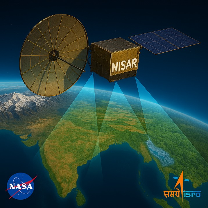
NISAR isn’t just another satellite launch; it’s a powerful collaboration between NASA (National Aeronautics and Space Administration) and ISRO (Indian Space Research Organisation) to build and launch an advanced Earth-observing satellite. Think of it as a super-sophisticated eye in the sky, equipped with cutting-edge technology to provide us with unprecedented insights into our planet’s dynamic systems – from the slow creep of tectonic plates to the rapid melting of glaciers and the health of our forests.
For us in India, NISAR holds particular significance. It’s a testament to the collaborative spirit of global science and promises to deliver crucial data relevant to our unique environmental challenges. But its impact stretches far beyond our borders, offering a global perspective on a planet undergoing significant change.
In this detailed blog post, we’ll embark on a journey to understand everything about the NISAR mission. We’ll delve into its purpose, the intricate launch details, its immense significance for both India and the world, the revolutionary technology it employs, the diverse applications of its data, and the profound impact it’s poised to have on our understanding of Earth. So, let’s get started and explore this incredible feat of human ingenuity!
What’s the Big Idea? Unpacking the Purpose of NISAR
At its heart, the NISAR mission is designed to provide a comprehensive view of Earth’s land and ice surfaces, measuring changes with remarkable accuracy over time. Its primary goal is to understand the intricate interplay of our planet’s natural processes and how they are being affected by both natural phenomena and human activities.
Think of it as trying to understand a complex machine with many moving parts. NISAR is equipped with sensors that can “see” through clouds and darkness, allowing scientists to collect continuous data on a wide range of phenomena, including:
- Deformation of the Earth’s Crust: Tracking the subtle movements of tectonic plates that can lead to earthquakes and volcanic eruptions. Imagine being able to map the strain building up beneath the Himalayas with unprecedented precision!
- Ice Sheet and Glacier Dynamics: Monitoring the melting rates of glaciers and ice sheets, crucial for understanding sea-level rise – a significant concern for coastal regions worldwide, including parts of India.
- Changes in Forest and Wetland Cover: Assessing deforestation, reforestation, and changes in wetland ecosystems, which are vital for biodiversity and carbon sequestration.
- Agricultural Productivity and Land Use: Providing insights into crop health, soil moisture, and land-use changes, which are directly relevant to our agricultural economy here in Bihar and across the country.
- Natural Hazards: Observing the impacts of floods, landslides, and other natural disasters in near real-time, aiding in disaster response and mitigation efforts.
NISAR’s unique capability lies in its ability to collect data in two different radar frequencies (L-band and S-band) simultaneously. This dual-frequency approach allows for more robust and detailed measurements of surface changes compared to single-frequency radar missions. It’s like having two different types of vision, providing a more complete picture of what’s happening on the ground.
Countdown to Discovery: Launch Details and Collaboration
The NISAR mission is a shining example of international scientific collaboration. It represents a significant partnership between NASA, with its expertise in L-band radar technology, and ISRO, contributing the S-band radar and the launch vehicle.
While the initial launch was anticipated earlier, as of my last update (October 26, 2023), the NISAR launch is targeted for the first quarter of 2024 from the Satish Dhawan Space Centre (SDSC) SHAR in Sriharikota, India. ISRO will be responsible for the launch using its powerful Geosynchronous Satellite Launch Vehicle (GSLV) Mark II.
This collaboration isn’t just about sharing hardware; it’s a fusion of scientific talent and engineering prowess from two leading space agencies. NASA’s Jet Propulsion Laboratory (JPL) is leading the U.S. component, responsible for the L-band radar, a critical part of the mission’s payload. ISRO’s contributions include the S-band radar, the spacecraft bus (the main body of the satellite), and the crucial launch services.
The very fact that these two space giants are working together on such an ambitious project underscores the global importance of understanding our changing planet. It’s a powerful message of unity in the face of shared environmental challenges.
Why NISAR Matters: Significance for India and Global Science
The significance of the NISAR mission is multifold, impacting both India and the global scientific community in profound ways.
For India:
- Enhanced Disaster Management: India is highly vulnerable to natural disasters like cyclones, floods, and landslides, particularly in regions like Bihar. NISAR’s near real-time monitoring capabilities will provide crucial data for early warning systems, disaster assessment, and relief efforts, potentially saving lives and minimizing economic losses.
- Agricultural Advancement: Agriculture is the backbone of India’s economy. NISAR’s ability to monitor crop health, soil moisture, and land use will provide valuable insights for farmers and policymakers, contributing to improved agricultural practices and food security. Imagine farmers in our own state getting timely information about optimal irrigation or potential crop stress based on NISAR data!
- Understanding Himalayan Geology: The Himalayas are a geologically active region, prone to earthquakes and landslides. NISAR’s precise measurements of crustal deformation will be invaluable for understanding the region’s tectonics and assessing seismic risk.
- Coastal Monitoring: With a long coastline, India is susceptible to sea-level rise and coastal erosion. NISAR’s data on ice sheet and glacier melt will contribute to a better understanding of these processes and their impact on our coastal communities.
- Forest and Environmental Monitoring: NISAR will play a crucial role in monitoring India’s diverse forest ecosystems, tracking deforestation, and assessing the impact of climate change on our natural resources.
For Global Science:
- Unprecedented Data Set: NISAR will be the first satellite mission to systematically acquire dual-frequency radar data over almost all land and ice surfaces on Earth every 12 days. This will create an unprecedented dataset for studying a wide range of geophysical and environmental phenomena.
- Advancing Earth System Science: The mission’s comprehensive and frequent observations will significantly advance our understanding of Earth’s interconnected systems and the complex interactions between the land, ice, and atmosphere.
- Climate Change Research: NISAR’s data on ice melt, forest carbon storage, and permafrost thaw will be crucial for refining climate models and predicting future climate scenarios with greater accuracy.
- Improving Disaster Prediction and Response: Globally, NISAR’s data will contribute to better forecasting of natural hazards and more effective disaster response efforts.
- Open Data Policy: Both NASA and ISRO are committed to making NISAR’s data publicly available to researchers worldwide. This open data policy will foster collaboration and accelerate scientific discoveries.
NISAR, in essence, is a powerful tool that will empower scientists globally to better understand our planet, its processes, and the challenges we face in a changing world. For India, it’s a particularly significant mission with the potential to directly address some of our most pressing environmental and economic concerns.
The Technological Marvel: Peeking Inside NISAR’s Toolbox
The capabilities of NISAR stem from its advanced and innovative technology. At its heart are its sophisticated radar instruments:
- L-band Synthetic Aperture Radar (SAR): Provided by NASA/JPL, this radar operates at a frequency of about 1.26 GHz (L-band). L-band radar is particularly good at penetrating through vegetation and dry snow, making it ideal for studying forest structure, soil moisture, and ice volume.
- S-band Synthetic Aperture Radar (SAR): Developed by ISRO, this radar operates at a frequency of about 3.2 GHz (S-band). S-band radar is more sensitive to surface roughness and moisture content, making it valuable for observing changes in land cover, snow wetness, and agricultural fields.
The “Synthetic Aperture Radar” technology itself is a game-changer. Unlike traditional radars that produce images based on a single pulse, SAR works by emitting multiple pulses as the satellite flies along its path. These multiple reflections are then processed using sophisticated algorithms to create high-resolution images of the Earth’s surface, regardless of cloud cover or time of day. It’s like creating a large antenna electronically, allowing for much finer detail than would be possible with a physically small antenna on the satellite.
Another key technological aspect is NISAR’s ability to perform interferometry. By precisely measuring the phase of the radar signals reflected from the Earth’s surface over multiple passes, scientists can detect even very small changes in elevation – down to centimeters. This is crucial for tracking the subtle movements of tectonic plates or the slight sinking of land due to groundwater extraction.
The satellite will also employ a large deployable reflector antenna, spanning approximately 12 meters, to transmit and receive the radar signals. Precise pointing and control systems will ensure that the satellite maintains its orbit and collects data accurately.
Furthermore, the mission incorporates advanced data processing and downlink capabilities to handle the massive amounts of data that will be generated daily. This data will then be processed and distributed to scientists around the world for analysis.
NISAR is truly a marvel of engineering, pushing the boundaries of remote sensing technology to provide us with an unprecedented view of our dynamic planet.
Putting NISAR to Work: Diverse Applications Across Disciplines
The rich dataset generated by NISAR will have a wide range of applications across various scientific disciplines and practical areas:
- Geology and Geophysics: Mapping fault lines, monitoring volcanic deformation, studying landslides, and understanding the dynamics of earthquakes. Imagine the potential for improved earthquake hazard assessments in seismically active zones!
- Glaciology and Hydrology: Tracking the movement and melting of glaciers and ice sheets, monitoring snowpack, assessing changes in permafrost, and studying surface water dynamics. This is critical for understanding water resources and the impacts of climate change on the cryosphere.
- Ecology and Forestry: Mapping forest cover, monitoring deforestation and reforestation efforts, assessing biomass and carbon storage in forests, and studying wetland ecosystems. This data will be invaluable for conservation efforts and understanding the role of terrestrial ecosystems in the carbon cycle.
- Agriculture and Food Security: Monitoring crop growth and health, assessing soil moisture content, mapping agricultural land use, and detecting early signs of drought or crop stress. This has direct implications for improving agricultural yields and ensuring food security, particularly in a country like India with a large agrarian population.
- Coastal Studies: Monitoring coastal erosion, studying changes in mangroves and coral reefs, and tracking the impacts of sea-level rise on coastal infrastructure and ecosystems.
- Natural Hazards and Disaster Management: Providing near real-time imagery and change detection maps for floods, wildfires, oil spills, and other natural disasters, aiding in rapid response and damage assessment.
The versatility of NISAR’s data makes it a powerful tool for addressing a wide array of environmental and societal challenges. Its ability to provide consistent, high-resolution data over extended periods will be invaluable for understanding long-term trends and the impacts of both natural and human-induced changes on our planet.
NISAR’s Footprint: Impact on India and the Global Stage
NISAR’s launch will undoubtedly leave a significant footprint on both India’s scientific landscape and global Earth science research.
For India, it will:
- Elevate ISRO’s Capabilities: The successful development and launch of the S-band radar and the spacecraft bus demonstrate ISRO’s growing expertise in advanced satellite technology and its commitment to Earth observation.
- Empower Indian Scientists: The availability of NISAR data will provide Indian scientists with a powerful tool to conduct cutting-edge research on issues of national importance, from agricultural productivity to disaster management and Himalayan geology.
- Strengthen International Collaborations: The partnership with NASA sets a precedent for future international scientific collaborations, fostering knowledge sharing and joint efforts to address global challenges.
- Direct Societal Benefits: The applications of NISAR data in areas like agriculture and disaster management have the potential to directly benefit the lives of millions of people across India.
Globally, NISAR will:
- Advance Our Understanding of Earth: The mission’s unique dual-frequency radar data will fill critical gaps in our understanding of Earth’s dynamic processes, leading to new scientific discoveries and improved models of our planet.
- Contribute to Climate Change Research: NISAR’s precise measurements of ice melt and changes in vegetation will provide crucial data for understanding the impacts of climate change and informing mitigation strategies.
- Foster Open Science: The commitment to making NISAR data publicly available will promote collaboration and accelerate scientific progress worldwide.
- Inspire Future Missions: NISAR’s technological innovations and scientific achievements will pave the way for future Earth observation missions with even greater capabilities.
The NISAR mission is more than just a technological achievement; it’s an investment in our understanding of our planet and our ability to address the challenges of a changing world. It embodies the spirit of scientific inquiry and international cooperation, promising to deliver valuable insights for India and the global community for years to come.
Conclusion: Looking Up with Hope and Scientific Rigor
As we eagerly await the launch of NISAR from Sriharikota, it’s inspiring to reflect on the journey that has brought this ambitious mission to fruition. The collaboration between NASA and ISRO, the ingenuity of the engineering teams, and the immense scientific potential of the data it will collect all point towards a significant step forward in our ability to observe and understand our Earth.
For us in India, NISAR offers a unique opportunity to address some of our most pressing environmental and developmental challenges with cutting-edge technology. From helping our farmers make informed decisions to providing crucial data during natural disasters, its impact has the potential to be truly transformative.
But NISAR’s significance extends far beyond our borders. It’s a global mission with the power to advance our understanding of the planet as a whole, contributing vital data to climate change research, natural hazard prediction, and a wide range of other scientific disciplines.
The data from NISAR will be a treasure trove for scientists worldwide, fostering new discoveries and collaborations. It’s a reminder that by working together and pushing the boundaries of technology, we can gain a deeper understanding of the complex world we inhabit.
So, as we look up to the skies in the coming months, let’s remember the incredible effort and scientific promise embodied by the NISAR mission. It’s a testament to human curiosity, our drive to understand the world around us, and our collective responsibility to protect our planet for future generations.
What aspects of the NISAR mission are you most excited about? Share your thoughts in the comments below!